 |
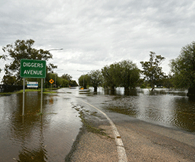
| Flooding is impacting Condobolin along the Lachlin River. --Photo ABC |
Severe thunderstorms, possible hail forecast across inland NSW as flooding continues
(ABC) -- Flooding and thunderstorms are continuing across inland areas of New South Wales, with the wet weather not expected to clear until Monday afternoon.
Affected areas include the south-west slopes, the Central and Southern Tablelands, the Riverina and ACT.
Pre-positioned aircraft are based in high-risk locations across the state, while a major resupply operation is underway today to provide essential goods to towns in need. “It spans an area more than 40,000 square kilometres of NSW. To put it into context, that is the size of Switzerland,” Minister for Emergency Services and Resilience Steph Cooke said.
“In these communities, we are resupplying food, medicines, animals with fodder. It is ongoing around the clock.”
Towns of concern are Wagga Wagga, Albury, Yass, Young, Forbes, Condobolin and others along the Murray River and Murrumbidgee systems. The Barwon catchment and its impact on Brewarrina and Collarenebri is also of concern, while the towns of Louth and Tilpa along the Darling River could move towards a record flood similar to 1976.
Along the Lachlan River, Condobolin and Euabalong may see flooding similar to the June 1952 flood, whilst Hillston is on track to meet the August 1990 flood level.
The Bureau of Meteorology said the severe weather, potentially including hail, would move from inland areas to the coast.
“The trough and a cold front will combine and begin marching across the state throughout the day and into Monday, and that will extend to the coastline and potentially the Sydney metropolitan area,” the Bureau’s Steve Bernasconi said.
“We do expect widespread rainfall to occur, around about 38 and 40mm across much of the state, and a very high chance of severe thunderstorms with intense rain, damaging winds and the potential for hail.”
However, he said the wet weather would likely ease by Monday afternoon.
“There is a positive side to this, that coming Monday afternoon and into Tuesday and out to Friday, we are looking at a spell of cooler, drier and more settled conditions,” he said.
NSW SES Commissioner Carlene York said the next 24 to 36 hours were of concern to volunteers.
She urged urging residents to remain vigilant and to not drive or walk through floodwaters.
“During the week, we passed one million sandbags going out to the community,” she said.
“We’ve ordered another 400,000 to make sure we can meet the ongoing need.
“That shows the community are listening and preparing but regretfully there are some people that aren’t.”
Residents in Forest Hill, an outer suburb of Wagga Wagga, are cleaning up today after an intense thunderstorm rolled through yesterday.
More than 60mm of rain fell within an hour on Saturday afternoon, causing flash flooding and damaging roads and some homes.
(Latest Update November 14, 2022)
|