Vientiane faces flooding threat
The city of Vientiane braces for flooding today, with low parts of Luang Prabang still underwater due to the rapid rise of the Mekong River and its tributaries.
Low-lying areas of Vientiane, which have no protection from embankments, face a high risk of floods from today as the water level of the Mekong rises rapidly, warned the Mekong River Commission (MRC) yesterday.
 |
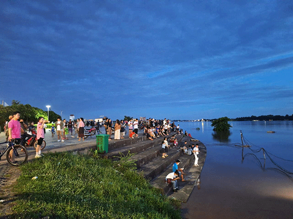
| Vientiane residents gather along the Mekong riverbank to observe the rising water levels. Authorities are warning those in lower areas of the city to prepare for potential flooding starting September 13. |
According to the intergovernmental organisation of Laos, Cambodia, Vietnam and Thailand, which forecasts water flow, low-lying parts of the capital, namely Nongda village in Sikhottabong district and several villages in Hatxaifong district, are facing flood risk from September 13.
The MRC says the central part of the capital remains safe for now due to the high river embankment.
However, it advises communities in low-lying areas to pay attention and make necessary preparations, including following instructions from their local authorities.
Some residents and firms in Vientiane have already erected sandbag walls around their buildings to prevent water from flowing into their areas in case of Mekong overflow.
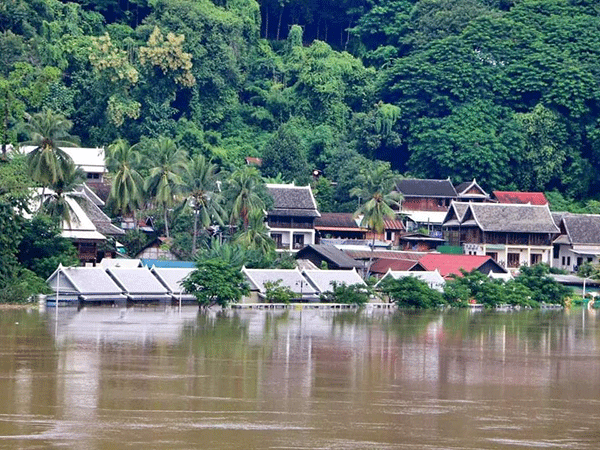
Meanwhile, the water level in Luang Prabang has risen above flood rivers, creating a high possibility of flooding in the world heritage town, with teams now mobilised to help people relocate themselves and their belongings to higher ground.
According to a notice from the Department of Meteorology and Hydrology under the Ministry of Natural Resources and Environment, the level of the Mekong in Vientiane and the provinces of Luang Prabang, Oudomxay and Xayaboury is projected to rise further during September 13-14, resulting in possible flooding.
On September 12, the meteorology and hydrology station in Luang Prabang measured the level of the Mekong at 19 metres, higher than the warning level of 17.50 metres and the danger level of 18.5 metres.
On September 13, the level of the Mekong in Luang Prabang is expected to increase to 20.5
Metres, and it could rise further to 21.5 metres on September 14.
The Vientiane station measured the Mekong at 11.34 metres on Thursday, whereas the flood warning level is 11.5 metres and the danger level is 12.5 metres.
 |
| The level of the Mekong River in Luang Prabang on Thursday. –Photo Wandee Sikhampheng |
However, the level of the Mekong River in Vientiane is expected to increase to 12.5 metres on September 13 and to 13.2 metres on September 14.
The Pakbaeng station in Pakbaeng district of Oudomxay province measured the Mekong at 29.9 metres, with the warning level in this area at 29 metres and the danger level at 30 metres.
The Paklai station in Paklai district of Xayaboury province measured the Mekong at 13.95 metres, with the warning level in this area at 15 metres and the danger level at 16 metres.
The central disaster management committee issued a warning yesterday that people living in Vientiane and Luang Prabang, Xayboury and Vientiane provinces, as well as people living near the Xechamphone River in Savannakhet province, should be prepared for extreme weather conditions and move their animals and other essential items to safe areas.
The committee urges people to monitor forecasts through newspapers, radio and television or visit the Meteorology and Hydrology Department’s Facebook page for updates.
Provincial authorities are to appoint teams to monitor the level of the Mekong closely and prepare officials, vehicles, equipment and aid to respond to disasters.
If there is a disaster, authorities are to help affected people promptly and speed up coordination with different sectors of society to respond to emergencies.
By Times Reporters
(Latest Update September 13, 2024)
|


